Part-time PhD Case Study: Matthew Clark
Matthew Clark works at the Met Office and is currently studying the conditions in which tornadoes develop along cold fronts for his part-time PhD at the University of Leeds. The research has identified statistically significant differences in the environment of tornadic and non-tornadic cold fronts for a large set of cases (114, of which 44 tornadic). A generalised measure of tornado risk has been developed based on two environmental parameters found to give the best discrimination between tornadic and non-tornadic fronts. It is anticipated that this will become a new operational tool for forecasting the risk of cold frontal tornadoes in the UK in the near future, and has already been used on an ad-hoc basis for a small number of recent events. Matt has additionally analysed the large-scale environments of tornadic cold fronts, identifying two weather patterns that account for the large majority of cases. Conceptual models have been developed to describe the salient features of each pattern, evolution of the pattern, and the typical timing and location of tornadoes relative to the identified features in each pattern.
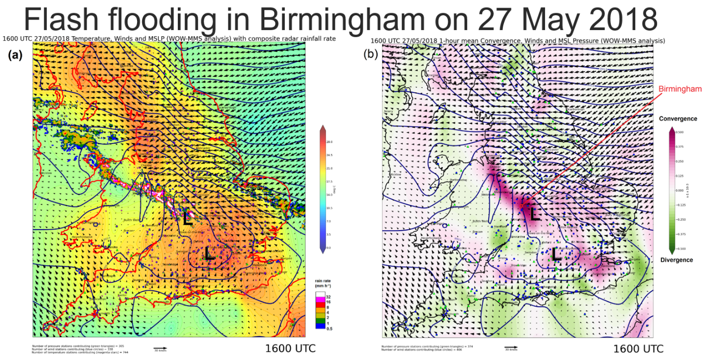
"The PhD has enabled me to look into the subject of cold frontal tornadoes in much more depth than I would otherwise have had time to do," Matt reported. "It has also provided an opportunity for me to work with new datasets and to develop new data analysis and processing methodologies. An example of this is filtering and bias correction of home weather station data to provide high-resolution surface analyses over the UK" (please see figure below).
Flash flooding images.
Surface analyses valid at 1600 UTC 27 May 2018, as derived from bias-corrected home weather station data. Left: temperature, wind and sea level pressure fields, with composite radar data overlaid. Right: wind, sea level pressure and horizontal convergence (shading) fields. The analyses show a mesoscale region of low pressure and a strong convergence zone over the Midlands (pink shading in right panel), along which intense thunderstorms broke out in the afternoon. These led to significant flash flooding in the Birmingham area.
Matt’s research is already showing some tangible outputs, as he outlined: “My PhD has benefited the Met Office by generating new tools to aid in the prediction severe UK weather. My work has led to the automatic generation of new analysis maps that inform forecasters where severe weather conditions are most likely to occur. A numerical index has also been devised to help predict the likelihood of tornadoes. The operational Met Office forecasters have been making use of the maps since 2018, and they have informed the decision-making process when issuing severe weather warnings in a number of high-impact thunderstorm cases".
If you or your company are interested in sending staff to study a part-time PhD at the University of Leeds, in the area of Fluid Dynamics please get in touch with us direct at [email protected]