Understanding weather through fluid dynamics
Professor Douglas Parker explains how adventurous, sky-high research in meteorology often starts with the study of maths and physics.
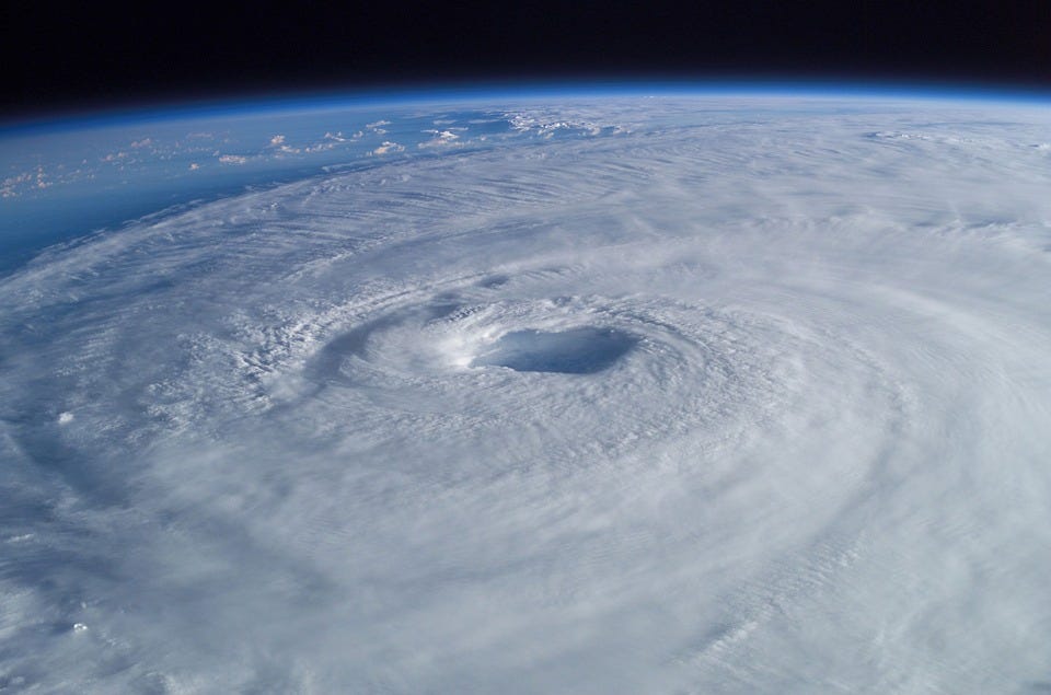
Heading intentionally into a storm, on an aircraft with 15 other scientists, it’s strange to think that mathematics is the reason you’re there. But if you study meteorology — the science of weather forecasting — then the most common route into the subject is through maths or physics.
Meteorology is essentially based on fluid dynamics — the movement and flow of air. Fluid dynamics are basic laws of physics, studied theoretically in maths, which can be applied across numerous fields including meteorology.
Because of the commercial drivers behind meteorology, such as shipping, aviation or agriculture, there’s always been demand for specialists in the field. Wider interest in meteorology expanded enormously in the 1980s, as people began waking up to climate change.
Now it’s even more in our minds as we are starting to see the human costs of severe weather events caused by global warming.
North south divide
Our ability to forecast the weather has always been better in Europe and the USA than the tropical countries of the global South. That’s partly a reflection of where the science was previously funded and carried out: scientists have tended to study where they live, and relatively few meteorologists lived in the tropics.
This is changing, partly as the science base grows worldwide and because the tropics are now known to be the “engine room” of the earth’s climate system, where the sun’s heating and the warm oceans provide energy to drive the global atmospheric circulation. The same laws of physics may apply everywhere on earth, but they can play out in very different ways.
Weather is affected by two main factors: the power of the sun (driving convection) and the effects of the earth’s rotation. In the UK, the latter has the greater impact, and the big rotating systems of highs and lows that dominate our weather are fairly stable and predictable. In the tropics, the power of the sun has a much greater influence.
Because the models we’ve developed for weather forecasting in the north don’t work as well in the tropics, we find tropical weather much harder to predict. In the UK, we tend to be sure of our weather 2–5 days ahead. This level of reliability does not exist in Africa and that has serious consequences for agriculture, power generation, fisheries and transportation. Every year, high-intensity weather events result in devastating losses of life and damages to land, property and infrastructure.
Storm warnings
GCRF African SWIFT (Science for Weather Information and Forecasting Techniques) is trying to improve these models and also find faster ways to get weather information to the people who need it.
This includes ‘nowcasting’, to provide immediate warnings of heavy rainstorms in the area — similar to tornado warnings in the USA. These short-term forecasts can be critical for some sectors, such as fishers at sea, or farmers bringing their goods to trade at open air markets.
Nowcasting is an example of maths in action. Projecting forward to see where a weather event might be headed in the short term is essentially a game of statistics. Like most weather forecasting, it also requires computational tools, such as machine learning and image processing.
Applying maths and physics in forecasting
Computing has taken over a lot of weather forecasting, taking humans out of the calculations. But that hasn’t reduced the need for meteorologists with the maths or physics knowledge to interpret what the computers tell us. And in the global South, people play an even greater role, given that the computer models are still a work in progress.
Meteorology also needs people to translate the science and communicate it to those who need it. And of course, it needs scientists who can work to improve the models in the first place.
An understanding of maths and physics underpins all these roles — which is why the partnership that’s been created between weather forecasting services and universities involved in the African SWIFT project, is so important.
Professor Douglas Parker explains:
“The universities supply the core skills, develop expertise and pass it on to their students. This greatly enhances their employability, whilst the meteorological services benefit from putting those skills and experience into practice.”
But without a partnership between the two, there’s a risk that the meteorological services become detached from the latest innovations in science and their skills become outdated.
Professor Douglas Parker:
“You don’t necessarily have to be a star at maths to be a good meteorologist, as so many other skills also come into play, beyond raw brilliance at equations. That’s probably why it’s a very diverse field — attracting those who like to put their maths into practice.”
Taking to the skies
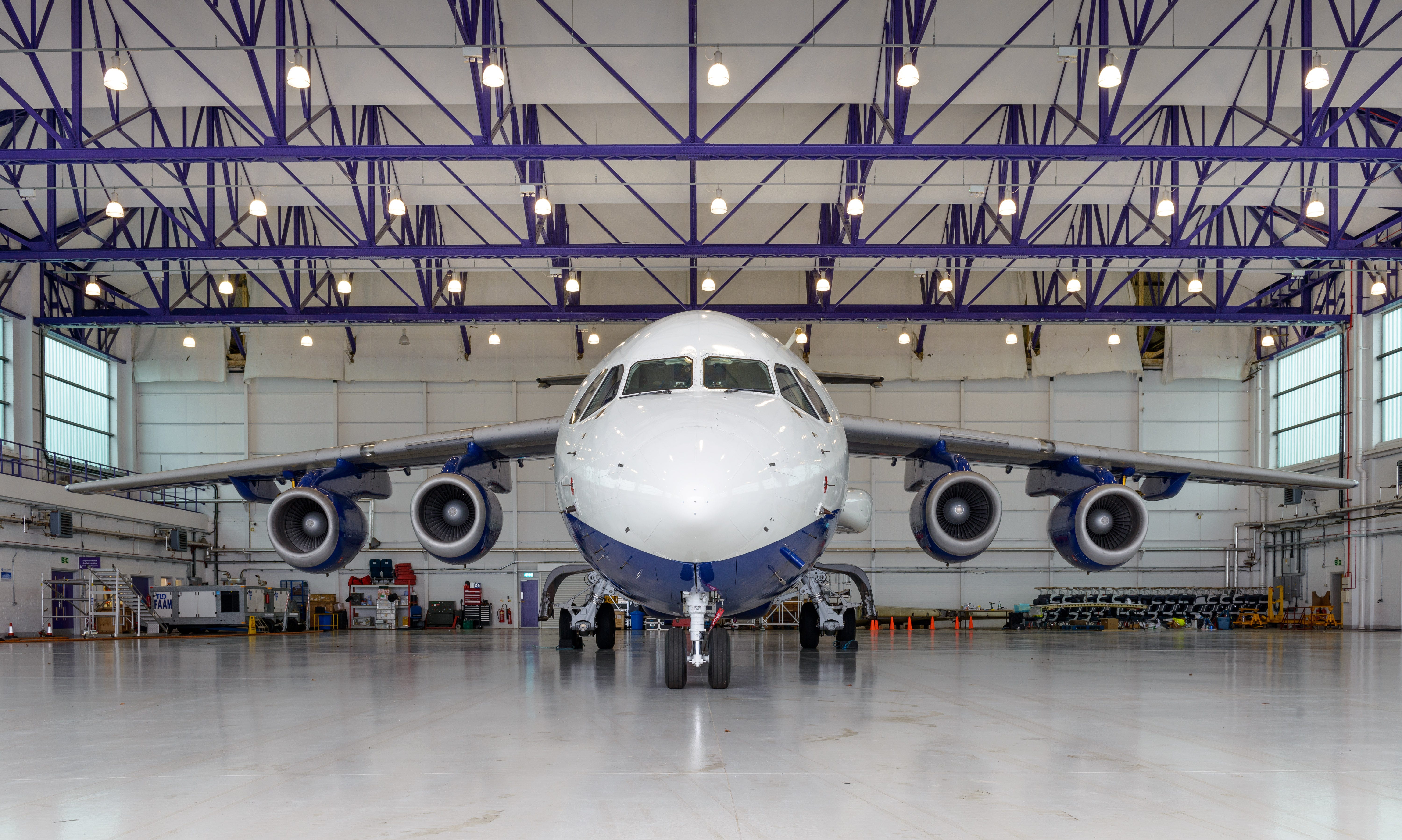
The Facility for Airborne Atmospheric Measurement’s Airborne Laboratory operates a big, four-engine jet aircraft that’s been converted with instrumentation to take measurements of many atmospheric properties, from pressure, temperature and winds, to atmospheric composition and air quality.
Owned by UK Research and Innovation and managed through the National Centre for Atmospheric Science, it’s primarily used by scientists from UK universities, research centres and the Met Office, and has been put to work around the world.
Professor Douglas Parker explains:
“I’ve flown in the FAAM research aircraft across the UK and wide areas of Africa and India, observing storms and cyclones as they develop over hills and plains and the adjacent seas. We have made detailed studies of clouds developing over patterns of plant cover, which can have a major impact on rainfall.”
A research flight lasts about 5 hours. There’s usually a team of around 15-18 scientists on board, each monitoring different aspects of the air, clouds and chemical composition in real time:
“The pilots make the ultimate decision on where to go, in terms of safety, but as mission scientist, you are responsible for guiding the aircraft according to the objectives of the mission. Your aim may be to get into the anatomy of a storm, to see a weather system in three dimensions — or even in four dimensions as you travel with a storm as it changes over time. It’s always thrilling, if occasionally a little bumpy!”
Meteorology may begin in maths but it touches so many other fields: climatology, geography, oceanography, plant sciences, social sciences and economics. It’s international by its nature: weather knows neither geographical nor political boundaries. It’s not likely to suit every mathematician or physicist, but if you can imagine yourself in that plane — then maybe it’s the place for you.
Visit the FAAM Airborne Laboratory website
Visit the GCRF African SWIFT website
Original article: https://medium.com/university-of-leeds/understanding-weather-through-maths-3aff429906fb